
Murasu Cyclone Tracker Live Satellite And Updates
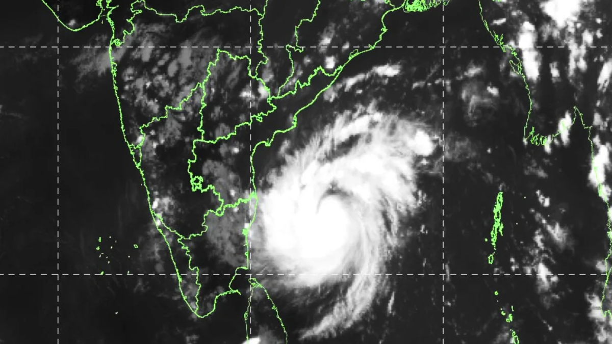
I have been refreshing the satellite loops every hour since this system formed. The structure changed fast. What started as a disorganized depression is now a compact severe cyclonic storm with a defined eye-like feature and cloud tops colder than -85°C.
If you are searching for the Murasu cyclone tracker live satellite, the short answer is this: landfall is expected between 11:30 PM tonight and 4:00 AM tomorrow, close to Ongole. The storm is holding strength. The window is closing. Here is what the latest data actually shows.
Where Murasu Is Right Now?
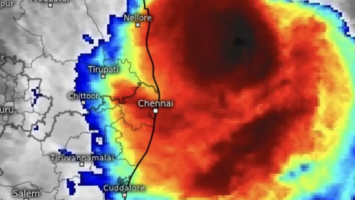
As of the IMD bulletin issued Monday afternoon, Murasu sits at roughly 13.9°N, 81.8°E. That puts it about 200 km east-northeast of Chennai, 210 km east-southeast of Nellore, and 260 km southeast of Ongole.
Read Also: Very Severe Cyclonic Storm Arnab: Path, Landfall Details, and Live Updates
The storm is moving west-northwest at 25 km/h. That speed matters. A slower storm would dump more rain in one place. A faster one spreads the impact but hits harder. Murasu is moving fast enough to keep the worst rainfall concentrated along the coastal districts.
Current intensity: severe cyclonic storm. Maximum sustained winds are 93 km/h gusting to 111 km/h . The IMD expects it to hold this strength through landfall.
The Landfall Window (And Why It Matters)
The forecast track puts Murasu crossing the coast between Nellore and Narsapur, close to Ongole. The timing is tight: 11:30 PM Monday to 4:00 AM Tuesday.
This is the worst possible window for coastal communities. People are asleep. Visibility is zero. Power lines are already vulnerable from the previous storm. If you live in the landfall zone, the next twelve hours are your evacuation window.
Wind speeds at landfall are forecast at 100-110 km/h, gusting to 120 km/h . That is enough to bring down trees, snap electricity poles, and tear roofs off kutcha houses. The Andhra Pradesh government estimates 6,000 to 8,000 electricity poles may be damaged .
The Satellite Picture Nobody Is Talking About
Three satellites are tracking Murasu. INSAT-3DS is providing thermal infrared imagery. The latest frames show a dense, bright cloud cluster with organized circulation over the west-central Bay of Bengal.
You Must Also Like: Will the 8th Pay Commission Be Implemented in 2026? Check New Salary Fitment Factor And Hiked Pay!
What the satellite doesn't show is the dry air intrusion. Microwave imagery revealed a slot of dry, convection-free air pushing into the western flank of the storm's inner core .
That dry air is the reason Murasu hasn't exploded into a stronger cyclone. It is also the reason the intensity forecast has uncertainty.
Some models show a severe cyclonic storm at landfall. Others show only a cyclonic storm. A few show just a deep depression.
The official IMD forecast holds Murasu at severe strength. But the spread in the models is real. Do not assume the storm will weaken before it hits. Prepare for the stronger scenario.
The Surge and Rain Threat
A storm surge of 1.0 to 1.5 meters above astronomical tide is forecast for the south coastal Andhra Pradesh at landfall. The highest surge is expected over Bapatla, Krishna, and Prakasam districts.
That is not a catastrophic surge. It is enough to flood low-lying areas and disrupt coastal roads. If you live in a flood-prone pocket near the coast, the surge is your primary risk, not the wind.
Rainfall is the other threat. Extremely heavy rain is likely at isolated places over coastal Andhra Pradesh tonight and tomorrow. Telangana may see isolated extremely heavy falls on Tuesday. Heavy to very heavy rain is also forecast for Tamil Nadu, Rayalaseema, south Odisha, and south Chhattisgarh.
The ground in southern Odisha is already saturated from Cyclone Arnab last week. That storm killed at least six people and forced over 180,000 evacuations . Fresh landslides are a real possibility in Gajapati and Gajapati districts .
What the Authorities Are Doing (And What You Should Do)?
Andhra Pradesh has deployed six NDRF teams and seven SDRF teams across the likely impact districts. Two teams each are stationed in Krishna, Bapatla, Guntur, Nellore, and Prakasam.
Odisha has prepositioned over 300 rescue teams comprising NDRF, ODRAF, and Fire Service personnel. Evacuations are underway in the southern districts.
If you are in the landfall zone, the advice is simple and non-negotiable. Move to a pucca building before midnight. Stay away from windows. Do not venture out during the lull that often comes when the eye passes.
Charge your phone now. Fill water containers. Keep a torch and batteries handy.
Fishermen have been advised not to venture into the west-central Bay of Bengal until Wednesday afternoon. Seas will be high to very high, with waves of 9 to 14 meters near the coast .
The Honest Caveat
Cyclone forecasts improve every year. They are still not perfect. The intensity spread in the models means Murasu could hit weaker than forecast, or stronger. The track could shift twenty kilometers north or south. The landfall timing could accelerate or delay by a few hours.
What will not change is the preparation window. If you are in the path, the time to act is now. The satellite tracker shows a storm that is organized, moving fast, and holding its strength. The next twelve hours decide how much damage it does to your home.
I will keep watching the loops. The storm is close. The coast is ready. The night will be long.